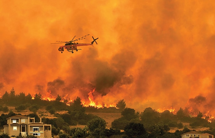
With wildfires around the world burning hotter and for longer developments in aerial firefighting technology are helping those battling the blaze gain the upper hand more rapidly. Jon Excell reports.
From the devastating blazes that reduced more than a million acres of California to ashes late last year to the ferocious flames that tragically killed 66 people in Portugal, 2017 was a record year for wildfires. Across southern Europe, lives were lost and homes destroyed as dry, hot weather and strong winds led to a doubling of the usual number of forest fires; meanwhile, in the US the forest service spent a record $2bn tackling the problem.
Furthermore, while 2017 was a dramatic year, experts fear we could see more of the same in the years ahead as a combustible combination of climate-change induced extreme weather and increasing levels of human activity in fire-risk areas fuels longer and more severe fire seasons.
Against this backdrop, with wildfires burning hotter and for longer, the skills and expertise of those charged with battling the flames are being tested to the limits. And fire experts, engineers and industry are working together to identify ways in which technology, from drones to AI simulation systems, can help firefighters – particularly those attacking the blaze from above – gain the upper hand more quickly.
The aerial firefighting process typically begins with the deployment of the sector’s special forces: so-called hot shots – elite wildland firefighters – and their even more exotically named colleagues, the smokejumpers, who risk their lives by parachuting in to the heart of fire-hit areas.
In an operation with obvious military parallels, these experts rapidly assess the situation, decide on a plan of action, liaise with ground crews and call in the water-bombers – aircraft that are used to either directly attack the blaze or, through carefully targeted indirect attacks, reduce its intensity and put down lines of retardant to stop it from spreading, and help crews on the ground tackle it head on.
A wide variety of fixed-wing aircraft and helicopters are used: from small, modified agricultural sprayers (so-called single-engine air tankers) able to drop around 3,000 litres (793 US gallons), through to much larger aircraft that carry retardant in huge tanks mounted on their bellies.
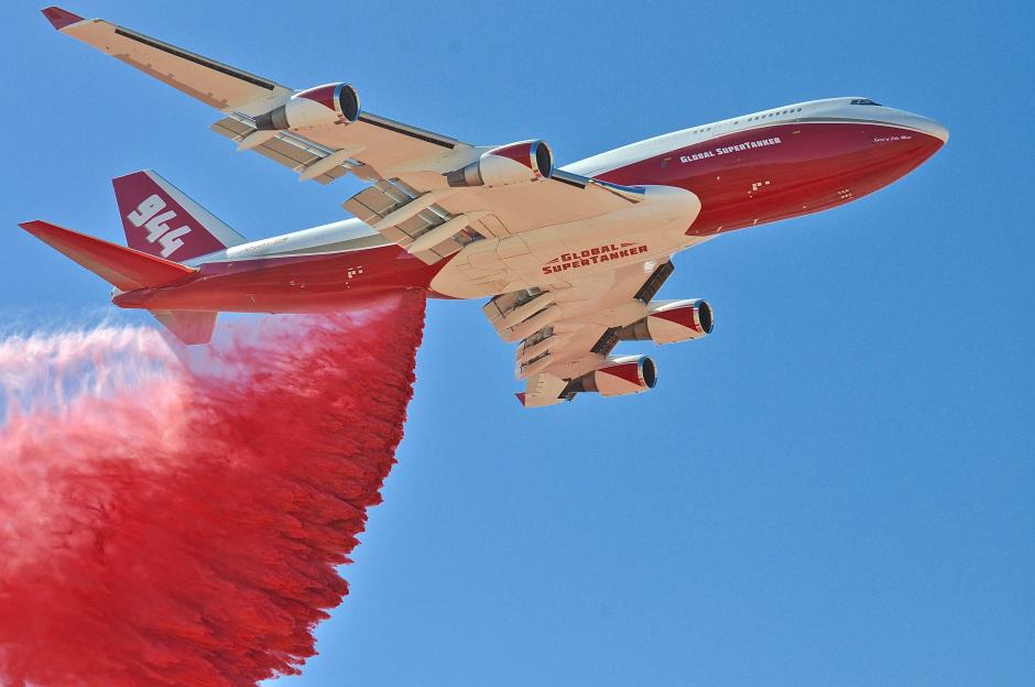
The undisputed monster of this curious backwater of the aerospace sector is the Global SuperTanker, a modified jumbo jet able to carry almost 73,000 litres (19,200 US gallons) of retardant. The aircraft, the only one of its kind, grabbed the headlines late last year when it was used to combat the wildfires in southern California.
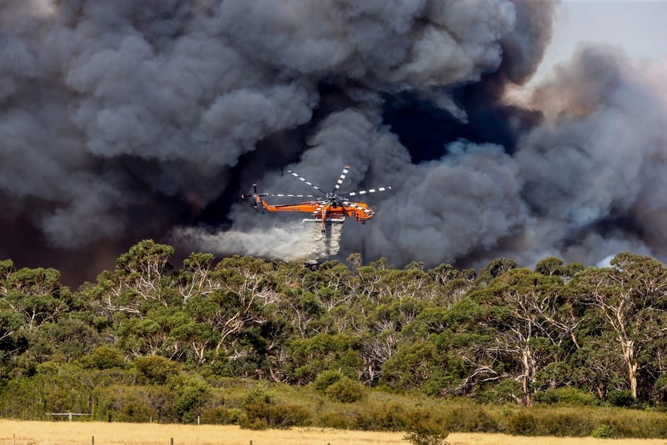
Although fixed-wing aircraft are typically used for indirect attacks (Global SuperTanker is reportedly able to lay down continuous retardant lines of up to 3km), helicopters, thanks to their hovering ability, are often preferred for direct attacks.
And, if Global SuperTanker is the beast of the fixed-wing world, its rotary cousin is surely Erickson Aviation’s S-64 Aircrane, a twin-engine heavy-lift helicopter able to hold almost 10,000 litres of water. Originally produced by Sikorsky as the S-64 Skycrane but heavily modified for firefighting, this unusual-looking aircraft was used alongside the Global SuperTanker to battle last year’s California wildfires.
According to Erickson’s chief pilot, veteran aerial firefighter Randy Erwin, a major benefit of the Aircrane is that it does not have to return to base to reload. Instead, it can suck up water wherever it finds it using a device known as a pond snorkel – essentially a flexible hose equipped with a pump that hangs below the aircraft’s landing gear.
“When immersed in a minimum of 18 inches of water, it will push water into the tank at a rate of 3,000-plus gallons per minute, and take [just] 40 seconds to get a full load,” said Erwin.
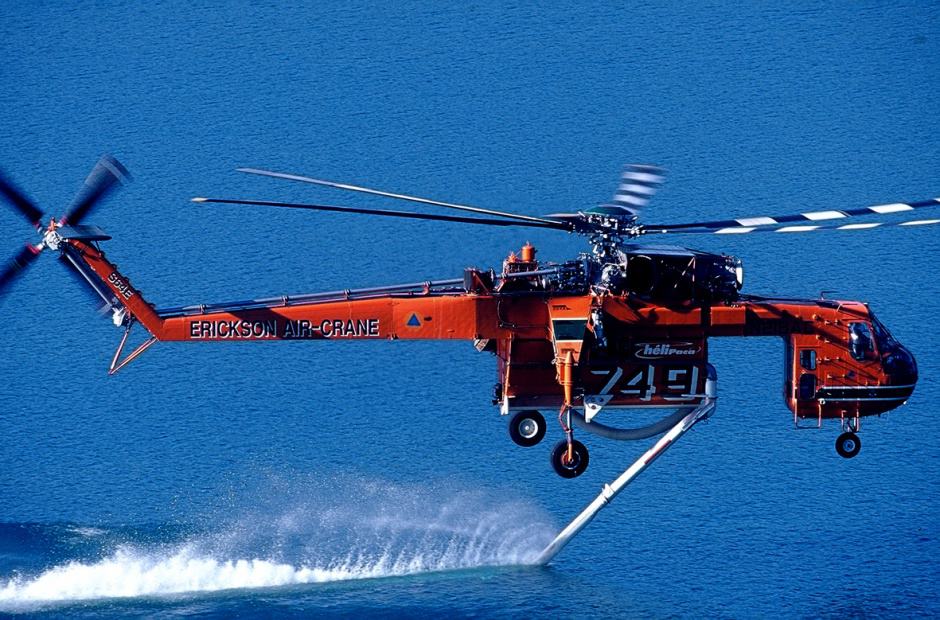
The Aircrane also boasts a salt-water derivative of the pond snorkel, which dispenses with the pump and fills the tank by holding the snorkel in place and using the forward motion of the helicopter to force water up its tube.
When it comes to dropping the payload, the aircraft uses water volume data from sensors within the tank to enable its pilot to precisely regulate the amount of water dropped on the fire: the so-called coverage level.
“If the tank knows how much water is in there, it can compute what the head pressure is on the doors. And, when the pilot selects [for example] coverage level 5 [equivalent to 5 US gallons of water per 10 square feet], the doors will open just enough to give that coverage. As the quantity in the tank decreases, it tells the door to open more and more to maintain the same rate,” said Erwin.
The headline-grabbing use of aircraft such as Global SuperTanker and Aircrane has certainly contributed to a perception that the wildfire battle has moved up a notch, but is the situation really getting worse?
Professor Johann Goldammer, a leading authority on wildfires and director of the Global Fire Monitoring Centre (GFMC) at Germany’s Max Planck Institute of Chemistry, is in no doubt. He told The Engineer that changing seasonal patterns linked to climate change were producing longer, more severe, fire seasons.
“A region like the West Coast of the US is experiencing an increasingly longer fire season that now seems to be all year long,” said Prof Goldammer, adding that this was being compounded by altered patterns of human behaviour.
“We are modifying the land by clear cutting, inhabiting, entering, industry, agriculture and so on. With this, the fire regimes and the vulnerabilities of ecosystems are changing.”
It’s a view shared by Bob Gann, acting director at the Colorado Center of Excellence for Advanced Technology Aerial Firefighting. “[Wildfires are] getting worse because people are intruding on areas and we are changing the field loads in the forest,” he said.
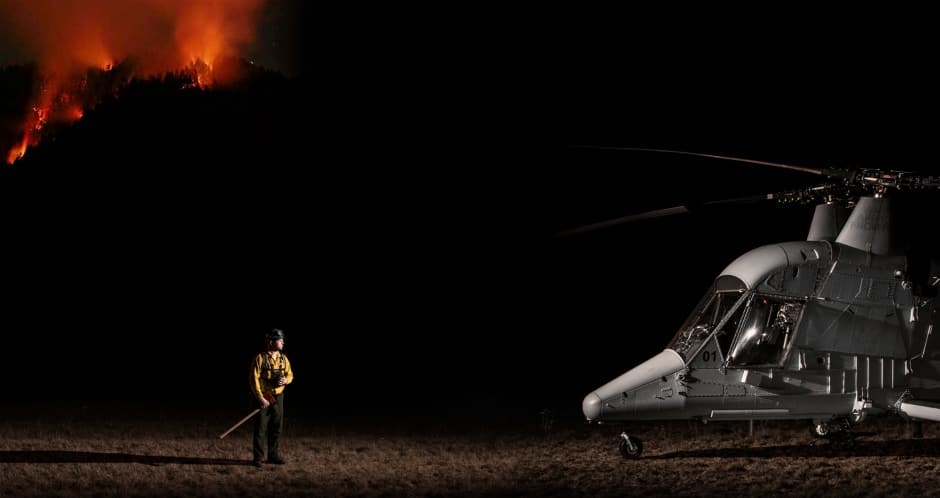
Gann’s team is at the forefront of exploring how technology can help firefighters meet this evolving challenge. A key avenue of research is the development of tools that could enable firefighters to tackle blazes at night.
In many ways the conditions at night-time are ideal for firefighting: reduced temperatures, increased humidity and often lighter winds cause fires to ‘stand down’, providing a window of opportunity for crews on the ground. Surprisingly, though, very little night-time firefighting takes place, with the advantages of more favourable conditions often outweighed by concerns over poor visibility and, consequently, an increased risk of collision.
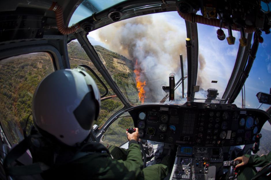
Night-vision systems similar to those used by the military seem to be a ready-made solution here. However, according to Gann, these technologies struggle with the contrast between darkness and the glare of a fire, and his team is investigating the application of augmented reality (AR) technology specially optimised for firefighting.
Similar efforts are under way in Europe. Jean Michel Dumaz heads the SAFE cluster in the south of France, a public organisation aimed at driving technology development and collaboration across a range of security and defence applications.
“In France, major stronger fires occur in the afternoon when the wind picks up and weather gets hotter,” he said, “But after 10pm the conditions are very good.”
Dumaz added that SAFE is currently supporting a project known as Extrem OWL, which is developing an augmented-reality vision system for firefighting helicopter pilots, led by French image-processing specialist Nexvision.
Another way of addressing the human risk of flying at night, of course, is to remove the pilot altogether by using drones, or unmanned air systems (UAS). In the US in particular, drones are already becoming an indispensable part of the wildfire fighter’s arsenal. The US Department of the Interior (DoI) operates around 350 remotely operated quadcopters, 100 or so of which are used specifically for firefighting reconnaissance and mapping missions. Last year alone the DoI flew around 660 flights to tackle 71 wildfires across the country.
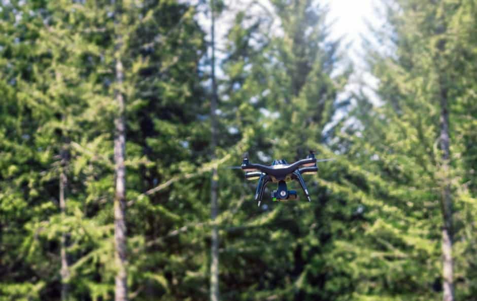
Brad Koeckeritz, the DoI’s division chief for unmanned aircraft, explained that drones provided a capability that did not exist before: enabling fire crews to carry out aerial reconnaissance when it was simply too dangerous to use manned aircraft.
“We had literally dozens of aircraft sitting on the ground in California because the smoke was too thick for them to fly,” he told The Engineer. “But we were able to use the drones and put VR goggles on one of the leaders on the fire-line that needed to know what the fire was doing.”
Increasingly, this capability is helping firefighters take swift action and prevent smaller fires from getting out of control. Koeckeritz said there were numerous occasions during last year’s operations in California when drones, operating in visibility too poor for manned aircraft, were able to detect spot-fires that had broken across the fire-line and direct resources to them.
Chad Runyan, UAS programme manager for the US Forest Service, which is a major user of the technology, added that the availability of drones was also making it easier to get other new systems in to the field.
“You can’t just put any old camera or transmitter onto a manned aircraft without going through many hurdles and sometimes years of approval processes,” he said. “But with a drone you can talk to a manufacturer and be off and running with the latest and greatest camera systems.”
While most existing applications are for monitoring and reconnaissance, Runyan envisages drones ultimately being used for firefighting. Far-fetched as this may sound, the forest service has already carried out unmanned firefighting trials, working with Lockheed Martin to demonstrate how an unmanned version of the Kaman Aerospace KMAX helicopter could be used to fight fires.
“You’re going to see people taking our existing fleet of aircraft and turning them into optionally piloted aircraft”, said Runyan, adding that this would enable agencies to move aircraft around the country in manned mode before switching them to unmanned mode in a firefighting zone.
Drones are also beginning to play a role in more strategic reconnaissance. During last year’s fires, California’s state firefighting agency used Reaper UAVs – military aircraft developed by General Atomics – to monitor fires and transmit information to commanders on the ground.
In the longer term, Koeckeritz thinks even higher-altitude autonomous vehicles, able to stay aloft for months at a time, will be a key tool in the firefighting armoury. The DoI has, he said, been actively studying applications of Google’s stratospheric balloon initiative, Project Loon, which is exploring the use of networks of high-altitude balloons to bring connectivity to remote areas.
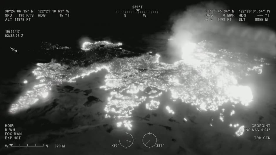
“We’re working with them to network a series of balloon systems in western states, for persistent communication systems, with camera systems at 65,000ft that can cover a wide area and be either looking for hotspots or doing mapping or a live feed,” he said.
Although the attraction of stratospheric systems is that they offer many of the advantages of satellites without the expensive launch costs, developments in satellite technology are also likely to help firefighters in the years ahead.
Sean Triplett of the US Forest Service said satellites had been used for a number of years to understand the impact of wildfires, but the emergence of cubesats – smaller, lower-cost devices that are becoming increasingly widely used by the research community – holds great promise for wildfire monitoring. These diminutive spacecraft could, he said, be launched into orbit in flocks of up to 200, providing far more persistent coverage than existing orbiting satellites, which typically passed by only every four to six hours.
“If they were on 15-minute repeat intervals, you’d be able to look at the same spot of land and start doing rapid-change detection as the fires were burning and the smoke was moving around,” said Triplett.
With drones, satellites, and stratospheric platforms providing a detailed, unblinking view of the drama unfolding below, there will be no shortage of data available to the future firefighter. However, arguably the biggest challenge of all is getting this information out into the field in a useful form as quickly as possible. This is particularly difficult in the US, which, unlike Europe, has patchy cellular coverage.
“The biggest problem we have when we fight wildfires is they’re in very remote rugged terrain,” said Triplett. “There are very limited databands available and, in most cases, the cellular network doesn’t exist.
“We’re not looking to send imagery to the firefighters; they don’t need pretty pictures. They want to see vector data: what the fire is and where it’s burning. The challenges are getting a disseminated product over a network that’s not designed to handle any sort of volume at all.”
A possible solution is being explored by Gann’s team in Colorado. Its ‘Datalink’ project is trialling a prototype radio system that could send basic situational awareness data such as points, lines and polygons directly to pilots’ smartphones.
“In the western US, a lot of places don’t have that much in terms of a network,” said Gann. “We need something we can apply to hundreds of firefighters, not just one or two.”
Gann’s team is also exploring how the data acquired by today’s monitoring systems could feed in to highly accurate fire-prediction systems – tools that could have a major impact on how firefighters plan their response.
Although fire-modelling simulations are already in use, the systems are limited, said Gann, partly because the weather data used is not very reliable. In an effort to change this, the Colorado team is working with the NCAR (National Center for Atmospheric Research) to develop a system using a detailed weather model called High Resolution Rapid Refresh, which is far more predictive than existing tools. Gann said the system was currently being validated and could be out in the field in just a couple of years.
Similar work is under way in Europe through the TechForFire project, an initiative led by French information systems specialist Noveltis, which is developing tools to combine live data acquired by cameras on the front line with weather models and wind information to predict how the fire will develop. SAFE’s Dumaz says the system is being trialled by several fire departments.
Back at the GFMC, Prof Goldammer is heartened and impressed by the speed of technical innovation. The biggest challenge as he sees it is ensuring that these various technologies are not developed in isolation; that industry and agencies around the world work together to share expertise and knowledge.
And, while it may be tempting to view wildfires as a local phenomenon and therefore unlikely to galvanise a concerted international approach, there is, he said, a compelling reason for a united effort: the fires that consume up to six million square km of land around the world every year are thought to be responsible for the net emission of 0.6 billion tonnes of carbon dioxide annually.
“Unlike other disasters, the emissions from these fires are all transported to the common, global shared atmosphere,” said Goldammer, “and the atmosphere doesn’t distinguish if this greenhouse gas is coming from a fire in California or Siberia. It’s there, it’s circulating around the world and it’s part of the increasingly warming atmosphere.”


April 1886: the Brunkebergs tunnel
First ever example of a ground source heat pump?