
Collaborate to Innovate 2019
Category: Information, Data & Connectivity
Winner: GeoSHM (GNSS and Earth Observation for Structural Health Monitoring)
Partners: University of Nottingham with the European Space Agency, UbiPOS, BRDI, Leica Geosystems, GVL & Transport Scotland
Category Sponsor: Babcock
When bridges fail it can result in huge loss of life, as the 2018 Ponte Morandi collapse so tragically demonstrated. That day in Genoa saw 43 people killed and 16 injured. While death tolls on this scale are mercifully rare, our C2I winner in the Information, Data & Connectivity category could help consign major bridge disasters to the pages of history.
GeoSHM (GNSS and Earth Observation for Structural Health Monitoring) uses multiple space technologies combined with in-situ sensors to provide a real-time picture of bridge movement and stresses. At the core of the system are GNSS (Global Navigation Satellite System) receivers that pick up positional data via the GPS, Galileo and BeiDou Navigation Satellite (BDS) constellations. This real-time monitoring is complemented by interferometric synthetic-aperture radar (InSAR) data provided by Earth Observation (EO) satellites that can track potential ground subsidence of the structure.
READ ABOUT THE OTHER C21 2019 WINNERS
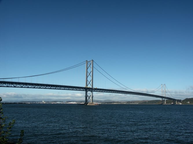
The technology is being brought to market by UbiPOS UK, a spinout from the University of Nottingham. Collaborating partners include Leica Geosystems, Geomatic Ventures Limited and China Railway Major Bridge Reconnaissance & Design Institute (BRDI). Various incarnations of the system have been deployed on the Forth Road Bridge (FRB) for over a decade, in partnership with Transport Scotland and current FRB operator, Amey.
“We started working with the Forth Bridge about 15 years ago,” Professor Xiaolin Meng, director of Nottingham University’s Sino-UK Geospatial Engineering Centre, told The Engineer.
“I think we have eight locations with more than 20 sensors on (the bridge). As you can imagine, we also have to have a communications link…initially we used optical fibres but in the end we found that optical fibres were not adequate, so we installed wireless communications on the bridge as well.”
CHECK OUT ALL THE C2I2019 WINNERS HERE
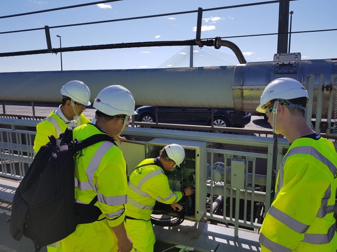
In November 2018, the consortium deployed its first all-in-one monitoring suite on the FRB, combining GNSS receivers with an accelerometer, antenna and communications module. The patent-pending kit sends real-time data back to users via the GeoSHM Analyst Toolbox, where AI and analytics help evaluate the overall structural health of the bridge.
Additional data on temperature, humidity, wind and traffic loading helps paint an even richer picture, with GNSS delivering positional accuracy of around 1cm in three dimensions. According to Professor Meng, the different individual sensor packages on the bridge not only utilise GNSS for position, but also rely on its timing signal to confirm that data from all nodes is synchronised. This ensures that fluctuations and flexes in the bridge’s deck and pylons are mapped correctly in real-time and that engineers can see precisely how the structure is moving at any given point.
“All sensors are actually synchronised with GPS time, which has nanosecond accuracy,” said Meng.
Away from the UK, collaboration partner BRDI in China has deployed a prototype system on two of its long-span rail bridges that cross the Yangtze river. China Railway operates more than 1,000 long bridges across the country, presenting a huge market opportunity for the technology. In 2020, GeoSHM will be installed on the Hutong Yangtze River Bridge, which will be the world’s largest cable-stayed road-rail bridge, reaching 1,092 metres with its main span.

“By collaborating with BRDI and providing our expertise in earth observation and monitoring technologies, we can help to improve the way that bridges are constructed,” said Meng. “The wide-reaching range of geospatial data that we are able to provide through our research work also has massive potential in helping to develop smart transport management solutions within the big cities in the UK and China.”
GeoSHM has been backed primarily by the European Space Agency (ESA), with additional financial support from Innovate UK, Amey and Transport Scotland. Now that the technology has been proven on multiple bridges, there are plans to roll it out across other major infrastructure. A large dam in China is set to have GeoSHM sensors deployed, while the consortium expects the market for monitoring high-rise buildings to be one of its biggest growth areas.
“In Dubai, we have an 800m high building, and how to safeguard these big assets is a challenge,” said Meng. “So, we’re trying very quickly to take this market on board.”
According to the Professor, opportunities are also being explored in the US, where the team is working in collaboration with AECOM. Though the country’s infrastructure presents a range of potential areas for expansion, Meng says the consortium is particularly interested in the dozens of bridges that serve New York City.
The Information, Data & Connectivity category is sponsored by Babcock
The headline sponsor for C2I 2019 is Frazer-Nash Consultancy


Red Bull makes hydrogen fuel cell play with AVL
Formula 1 is an anachronistic anomaly where its only cutting edge is in engine development. The rules prohibit any real innovation and there would be...