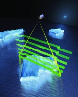
To pin down this location in the foreand aft-direction, SIRAL uses a synthetic aperture technique to measure the angle of signal on arrival. To do this at Earth’s poles, CryoSat-2 must fly at an unusually high inclination, reaching latitudes of 88˚ north and south. This is greater than any satellite currently in space and will result in an additional area coverage of 4.6 million km2 – more than the area covered by all 27 EU member countries.
Fixed panels of solar arrays power CryoSat-2. ’This is another unusual feature,’ added Francis. ’Other satellites have solar arrays that are rotating on an arm so they constantly face the sun. With CryoSat, we wanted to reduce the number of moving parts. This is partly because they are susceptible to failure, but also because they are expensive. In the 1980s, we used to say every single moving mechanism, be it a hinge or whatever, will cost you at least £1m. I’m sure that’s even more today.’
The only moving parts on CryoSat-2 are the valves controlling its propellant movement. But to remove the hinges and install flat solar arrays, the engineering team had to use one of the world’s most efficient solar cells. ’These are triple-junction gallium arsenide cells,’ said Francis. ’They are around 28 per cent efficient, which is quite remarkable. In space, without the atmosphere, you are getting around 1,600W per m2 out of the sun. With 28 per cent of that, you’re in pretty good shape.’
If all goes well, CryoSat-2 will send a flood of scientific data about the planet’s ice sheets to an antenna located in the far north of Sweden. The additional information about the polar regions will allow scientists to undertake more sophisticated analysis interactions of the ocean with the atmosphere.
Alan O’Neill, director of the National Centre for Earth Observation, said: ’The key point to make about polar regions is not only are they early indicators of climate change, but also they are not distant from what affects people’s lives and the weather that affects the rest of the planet. They are connected by Earth’s “bodily fluids” (the ocean and atmosphere) and changes in the polar regions can significantly affect circulation patterns in both parts of that system.’
To ensure CryoSat-2’s data is accurate, ESA is also carrying out large-scale expeditions to the Arctic and Antarctic to understand natural sources of error. These could range from changes in snow wetness, the weight of snow on top of sea ice, and variations in snow and ice density over a particular area. The land-based measurements will involve equipment such as ground-radar and neutron probes, as well as more traditional techniques such as digging in snow pits. A number of polar explorers inspired by the CryoSat mission have also volunteered to take measurements of snow-depth in their journeys across the Arctic.
’I think the days when we send huge satellites into space are numbered,’ said Francis. ’In the future there will probably be a tendency towards smaller satellites and ones with increased capability. In fact, my next job is to build the future Jason satellite based on CryoSat. And from there there’s nothing stopping us building other satellites with an even higher inclination to better understand the polar regions.

The Data
The key facts about the satellite
- Launch: April 2010
- Orbit: Mean altitude of 717km and inclination of 92˚, non-Sun-synchronous
- Duration: Three years (following a six-month commissioning phase) with a possible extensio
- Mass: At launch 720kg, including 37kg of fuel
- Power: Two GaAs body-mounted solar arrays, each delivering 850W; 78 AH Li-ion battery
- Configuration: Simplified rigid structure. Dimensions of 4.6 x 2.4 x 2.2m
- Mission control: Mission control from ESA’s European Space Operations Centre (ESOC) in Darmstadt, Germany
- Payload: SAR Interferometric Radar Altimeter (SIRAL), supported by Doppler Orbit and Radio Positioning Integration by Satellite (DORIS) and Laser Retro-Reflector (LRR)
- Data Processing: Data distributed direction to users from the ground station in Kiruna; distribution and mission planning managed via ESA’s Centre for Earth Observation


Nanogenerator consumes CO2 to generate electricity
Whoopee, they've solved how to keep a light on but not a lot else.