
The next generation of imaging techniques could be a game changer for archaeology. Jason Ford reports
Why would we preserve something if we can’t understand it? This question is being asked by Dr Chris Gaffney, an archaeologist whose work has helped to provide fresh insights into one of the world’s most intriguing archaeological sites.
Gaffney is head of Archaeological Sciences at Bradford University and part of the Stonehenge Hidden Landscape Project (SHLP), which last year announced the discovery of a major new prehistoric stone monument less than 3km from Stonehenge.
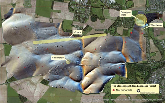
Using a combination of remote sensing and non-invasive geophysical prospection techniques, the project team found evidence for a row of up to 90 standing stones, a discovery that prompted one commentator to suggest that everything written about the Stonehenge landscape and ancient monuments within it be re-written.
“As archaeologists… we instantly turn towards the [Stonehenge] monument because we see that as the focal point in the landscape, which of course it is. But actually it’s the focal point of quite a complex landscape, and one that we now know is even more complex thanks to remote sensing.”
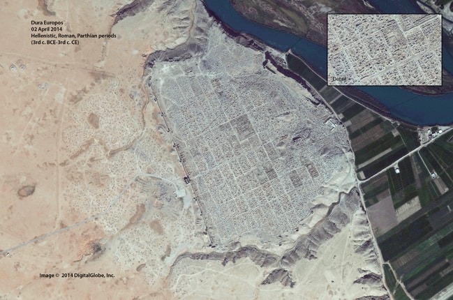
SHLP’s revelation that a large stone monument lay beneath the bank of the so-called Durrington Walls ‘super-henge’ was preceded in August 2015 with an announcement from the FBI that ‘industrial-level’ looting was taking place at archaeological sites in Syria and Iraq.
The FBI produced evidence of looting in the form of satellite imagery taken between 2011 and 2014 at three sites over Syria, a method of investigation used by Sarah Parcak, an associate professor of anthropology at the University of Alabama.
Like the FBI, Parcak has used repeatable, high-resolution satellite imagery from DigitalGlobe’s WorldView-2 in a project to identify and quantify looting sites in Egypt following the overthrow of the nation’s government in 2011.
According to Parcak, the project revealed a 400 to 500 per cent increase in looting in since 2011, and she believes that there is a 20- to 25-year window until many of the world’s archaeological sites are lost to looters, all of which detracts from the work of archaeologists whose efforts have been aided by aerial imagery since 1906 when Stonehenge was photographed from a balloon and is now helped by airborne platforms carrying a myriad of imaging techniques.
Parcak is the 2016 winner of the US$1m TED Award for work that used infrared satellite data to find the ancient Egyptian city of Itjtawy, and the 2014 launch of DigitalGlobe’s WorldView-3 satellite is expected to facilitate further discoveries with Short-Wave Infrared (SWIR) capabilities that have added spectral coverage to the invisible range to help identify minerals and specific vegetation, a function that will help archaeologists detect sites of interest more easily.
Benoit Duverneuil, founder of Aerial Digital Archaeology & Preservation (ADAP), said that satellite imaging helps archaeologists understand subtle geophysical changes on a large scale over a short or long period of time and Gaffney believes archaeology would be “in a pretty poor place” without Earth observation satellite technology. He has used imagery from NASA’s Landsat program to identify archaeologically significant data at the UNESCO World Heritage Site of Cyrene in Libya.
“Archaeologists are real predators when it comes to other people’s data,” said Gaffney. “As soon as people have started to provide new data sets archaeologists have been very keen to grab hold of them to see if they can use them for their own purposes.”
However, despite the repeatability brought about by orbiting Earth, issues arise around the timing of data acquisition, ownership of what is captured, and costs.
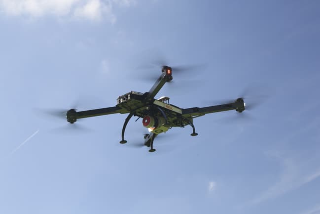
“One of the problems with satellite data [is] you either collect data from flights that have passed over at a given time, or pay huge, huge amounts of money for newly collected data, which is well out of reach, certainly for people in archaeology,” said Dr Adrian Evans, a post-doctoral research fellow at Bradford’s Department of Archaeological Sciences, who is working on Fossil Finder, a project using a customised UAV to capture surface imagery of fossil-bearing areas around the Turkana Basin in Kenya. Images from flights are uploaded onto the project’s website where members of the public are encouraged to help in the identification of fossil fragments.
According to Evans, the team has been working with a DJiS1000 multi-rotor UAV fitted with a Pixhawk auto-pilot system, which is based on open-source software that is one-tenth of the cost of commercial autopilot systems.
To achieve a resolution of three pixels per millimetre on the ground without motion blur the team fitted the UAV with a Sony A7R series camera, which was superseded by an A7R MKII to take advantage of the camera’s CMOS sensor.
“It’s the highest resolution you can get,” said Evans. “Even though it’s really bright in Africa we’re shooting at such high shutter speeds that we’re actually dealing with low-light situations so we needed a really good-quality sensor.”
While Parcak’s work in Itjtawy required satellite coverage from a zone measuring four miles by three miles, the Fossil Finder project is using its flight capability to cover more modest areas, starting with a sector measuring 100 x 40m to establish a raster pattern, although Evans anticipates this to rise to 10km a day from March when the UAV will fly 1km sorties. He added that images collected are extracted from the on-board camera’s SD card after each flight.
Gaffney is involved in a project based around cultural transformations in Iron Age Slovenia and Croatia, the former country being one of the most densely wooded in Europe. By using LiDAR (Light Detection And Ranging) mounted on commercial aircraft, the team is able to ascertain complete landscapes that are preserved beneath the tree canopy.
LiDAR, which uses light sensors to measure the distance between the sensor and the target object in order to build a 3D image, is slowly making it onto unmanned systems, notably on board the Riegl RiCopter fitted with a VUX-1UAV LiDAR sensor.
Duverneuil, whose Miami-based research group facilitates non-invasive prospecting through remote sensing, believes LiDAR is becoming more affordable, lighter and compatible with UAVs but will remain out of reach for many archaeological projects for the time being, a point endorsed by Gaffney.
“In the next decade or so we’re probably going to see quite a diversification whereby we’ll get more standard, miniaturised sensors onto drones and some very specific things onto satellites,” said Gaffney. “The satellites will perhaps be very much more focusing more on particular spectra, whereas we’ll see the more general data collection being done on drones.”
In the interim, Evans is convinced that plummeting prices for UAVs will see greater uptake of the technology by archaeologists, as does Duverneuil who believes that with a budget of less than US$2,000, professional aerial photogrammetry will be something of a game changer for archaeologists.
“With the help of software such as Pix4D Mapper Capture or Drone Deploy (freemium), flight planning, execution, data capture and processing is all done automatically,” he said. “We can even preview the results in real time, which is a major improvement for archaeologists.”
Duverneuil also sees no reason why satellite and drone data cannot be used in tandem for archaeological projects.
“The use of UAVs doesn’t really dismiss the role of satellite imagery,” he said. “In fact, archaeologists have now the possibility to use a multi-scale approach for their project. Depending on the stage of their research, the type of data they want to collect, the area they need to cover and their budget, they [archaeologists] can rely on different technologies. UAVs are usually more efficient to survey a small area at a lower elevation even though modern v-wing UAVs can produce hi-definition images for quite large areas.”
Ultimately, while satellite imagery and UAVs have a part to play in discovering and recording archaeological sites and landscapes, they are only tools in an arsenal of techniques that should be deployed together.
“The actual concept of archaeological prospection is not just about techniques,” said Gaffney. “It’s about process, [and] it’s sometimes about serendipity. You might spend a year looking through satellite imagery and only finding what you already know. But ultimately, on that extra day that you look, you might find something extraordinary and I always think you have to have that little bit of luck in what we do, no matter how robust our strategies are.”


Collaboration to address viable solutions for VAWG database
<blockquote>address the lack of standardisation, coordination, and collaboration of gender disaggregated data intelligence across various regions,...