A geographer from Leicester University has produced a map of the scorched Earth for every year since the turn of the Millennium.
Dr Kevin Tansey of the Department of Geography, a leading scientist in an international team, created a visual impression of the fire scars on the planet between 2000 and 2007. The work was funded by the Joint Research Centre of the European Commission.
The map reveals that between 3.5 and 4.5 million km2 of vegetation burns on an annual basis, an area equivalent to the European Union.
The information could be used by scientists involved in monitoring global warming, measuring and understanding pollutants in the atmosphere, managing forests and controlling fire and even for predicting future fire occurrence.
'We have produced a global data base and map of the occurrence of fire scars covering the period 2000-2007. Prior to this development, data were only available for the year 2000. With seven years of data, it is not possible to determine if there is an increasing trends in the occurrence of fire, but we have significant year-to-year differences, of the order of 20 per cent, in the area that is burnt,' said Dr Tansey, a lecturer in remote sensing at Leicester University.
Tansey undertook the work with colleagues from the Joint Research Centre of the European Commission (Italy) and the Université catholique de Louvain (Belgium).
'This unique data set is in much demand by a large community of scientists interested in climate change, vegetation monitoring, atmospheric chemistry and carbon storage and flows,' claimed Dr Tansey.
'We have used the VEGETATION instrument onboard the SPOT European satellite, which collects reflected solar energy from the Earth’s surface, providing global coverage on almost a daily basis. When vegetation burns the amount of reflected energy is altered, long enough for us to make an observation of the fire scar. Supercomputers located in Belgium were then used to process the vast amounts of satellite data. At the moment, we have users working towards predicting future fire occurrence and fire management issues in the Kruger Park in southern Africa,' he added.
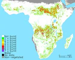
This map shows the occurrence of fire activity in sub-Saharan Africa, determined by detection of the fire scar, for a seven year period 2000-2007
The majority of fires occur in Africa. Large swathes of savannah grasslands are cleared every year. The system is sustainable because the grass regenerates very quickly during the wet season. From a carbon perspective, there is a net balance due to the regenerating vegetation acting as a carbon sink. Fires in forests are more important as the affected area becomes a carbon source for a number of years.


Glasgow trial explores AR cues for autonomous road safety
They've ploughed into a few vulnerable road users in the past. Making that less likely will make it spectacularly easy to stop the traffic for...