Amongst the tools we now have at our disposal to help us reduce carbon emissions, one vital, natural instrument has been helping us to fight the battle all along: our global rainforests.
Thought to absorb around a third of the world’s CO2 released from burning fossil fuels each year, forests are an integral piece of the net zero puzzle. Yet, rising temperatures and deforestation are having a devastating effect on the planet with forests burning worldwide and releasing carbon back into the atmosphere.
Measuring the progress of our forests and the role they play in the carbon cycle is a critical step in managing the planet’s natural resources and working toward positive change.
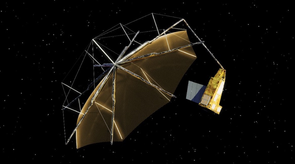
Through the new satellite being built by Airbus Defence & Space as part of the European Space Agency (ESA) Living Planet Programme, scientists will be able to improve this understanding by measuring the biomass within the world’s rainforests at unprecedented accuracy levels.
Carl Warren, Airbus’s chief engineer on the Biomass project explained that if we look at today’s global carbon budget, showing the balance between how much carbon is emitted and how much is absorbed by the oceans and forests, the land in relation to forests is the biggest area of uncertainty.
MORE NET ZERO NEWS AND FEATURES FROM THE ENGINEER
According to the ESA, the land-use change flux - the difference between emissions from forest loss, and uptake of carbon dioxide from forest regrowth - has an uncertainty of around 54 per cent of its estimated value.
“Biomass is all about narrowing down those error bars to have a much better confidence in our estimate of how much carbon there is in the world's forests as a baseline, and then to monitor that through the course of emission to see how it changes and evolves,” Warren told The Engineer.
“All of that information will then be able to be used by the climate change modellers to improve and update their modelling, to improve the [precision] of this aspect of the modelling and the predictions of how things might change.”
The data will also inevitably be used to help guide policy in terms of how the forests should be managed and how countries should aim to reduce emissions, he added.
The Biomass satellite will utilise a fully polarimetric P-band Synthetic Aperture Radar (SAR) at 435 MHz to make measurements of the forest biomass, at an altitude of 666km in dawn-dusk, sun-synchronous orbit. This is the first time the P-band frequency has been used to make measurements from space, having previously been limited to use from aircraft.
Bringing a wealth of expertise in SAR technology is the mission’s principal scientist, Professor Shaun Quegan. Based at Sheffield University and a member of the UK National Centre for Earth Observation, Quegan has a long history of working with SAR, carbon cycle studies and ionospheric physics. His work has been one of the key drivers behind the mission’s origins back in 2005, when the proposal for Biomass was submitted to the ESA following approval from the International Telecommunication Union to utilise the P-band frequency from space.
“Almost all of the countries with extensive tropical forests contain in their Nationally Determined Contribution, from the Paris Agreement, some commitment to forest activities — to either increase forests, manage them better or cut down degradation,” said Quegan.
“These forests are huge, they’re remote and they can be very difficult to get into. In the past, I’ve asked people in Borneo if they could make a measurement in this area and they’ve said no, not a chance: it’s just not possible to get there. Tropical forests have never been managed like they have in the Northern hemisphere.”
You’ll get this interesting layered view of the biomass through the world’s forests, which is a complete world-first. Nobody has done that before
- Carl Warren, Airbus Defence & Space
Quegan explained that whilst many international countries have forest inventories with extensive measurements, there are very few of these within the tropics. And aside from cutting down a tree, there isn’t a reliable and accurate method of measuring its biomass on the ground without dealing with large degrees of uncertainty.
Over five years, the mission will embark on two phases. The first phase, hailed by Quegan as the mission’s most radical measurement technique, is the Tomographic phase. This will take place for just over a year and will provide a reference data set of the global forests’ structure by measuring seven layers of data in an individual location and processing it to allow for a layered image. Warren described the process as ‘CAT scanning the world’s forests from Space’.
“You’ll get this interesting layered view of the biomass through the world’s forests, which is a complete world-first. Nobody has done that before,” he said.
For the remaining four years, the mission's second phase — the Interferometric phase — will combine the remote sensing technique of SAR interferometry with backscatter measurements to produce estimates of forest biomass and height.
“The whole development of the design is interesting. People have this idea that you think of the satellite idea, then propose it and build it but it’s not like that at all: what we proposed in 2005 and what we’ve actually got now are not the same beast,” said Quegan.
“The political context is different, what we know is different and the design of the radar is different. There was no tomography in the first design because that wasn’t a particularly well-developed technique, whereas now it is.”
Tomography’s role went from being an experimental factor taking place at the end, to appearing upfront due to the realisation of its value to the mission, Quegan added, emphasising that the process has been one of learning and will continue to be throughout the entire mission's lifecycle.
The satellite has an overall launch mass of 1250kg, and includes a 12m projected circular aperture large deployable reflector. Most of its materials and technologies are ‘fairly conventional’, Warren said, similar to those used for the company’s telecommunications satellites — the mechanical structure itself is made from aluminium honeycomb panels, the reflector system uses carbon fibre for its structural element and the solar ray uses triple-junction gallium arsenide cells.
Airbus makes around five or six commercial satellites a year, meaning the company is well-placed to draw on its expertise and existing facilities for a mission of this scale, he added.
“There’s a lot of technology in this that draws on our commercial satellites — the structure, for example. We didn’t make the structure in terms of manufacturing the panels, with our telecoms satellites we do, but it’s the same technology so we’ve leveraged the experience we have with that technology to do this. Same with the propulsion systems, and all in all as much as possible to keep risk down in the development of this, so the risk is really focused primarily on the instrument, the new bit,” Warren explained.
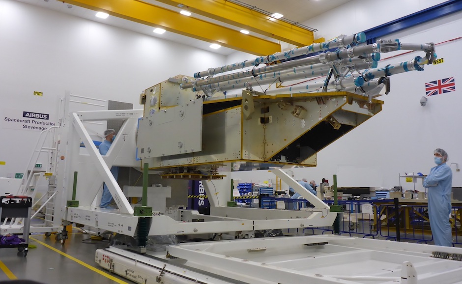
Having passed its critical design review earlier in 2021, Airbus is now well into building the flight model of the space craft working closely with its industry partners.
“The platform part of the space craft with the avionics and propulsion systems is being assembled, and should be complete towards the end of the year,” said Warren. “We’ll finalise testing here in Stevenage [at Airbus], then we will ship to do the environmental test campaign in Toulouse.”
This stage will involve simulating the launch environment, putting it into a thermal chamber and operating it at high and low temperatures to ensure it works within the vacuum and the thermal environment it’ll see in orbit, he added. Following this, an EMC test will take place to ensure it’s all electromagnetically compatible, particularly the radar.
Testing will run throughout the end of 2022 and into early 2023, ahead of integrating the reflector and preparing to launch some time in mid 2023 from Kourou, French Guiana.
Key engineering challenges involved in building the satellite included the constraint of fitting the satellite into the launcher, which Warren explained is one of the smaller launchers available on the market.
Safe deployment of the reflector also had to be taken into consideration, ensuring the space craft can be controlled properly during all phases of the mission, and achieving the required mission performance whilst constrained by power limitations is another notable barrier to break through.
“We’re a secondary user of the 435MHz frequency band. We only have 6MHz of frequency to use, and we were limited by how much power we could put down, so that inevitably brought some challenges around how the instrument was designed in order to achieve that mission performance,” Warren said.
Quegan pointed out that from his perspective, using the knowledge of physics to gain further understanding of the signals is the biggest challenge of the mission.
“Even though we knew the P-band backscatter was sensitive to biomass, the physics of that were not properly understood, the models were too primitive, so there’s been a lot of work on exploiting the models in the estimation procedure,” he said.
Another aspect is that satellite missions rely on ground data, of which we know is very limited in the tropics. The novelty of using P-band frequency from space also means that data to study this method has been restricted and will result in a lot of further learning on the job, he concluded.
The whole development of the design is interesting ... what we proposed in 2005 and what we’ve got now are not the same beast
- Professor Shaun Quegan
Collaboration has been essential for the team, working with ESA and with NASA’s Global Environmental Dynamics Investigation (GEDI) mission launched in November 2019. GEDI makes LiDAR (Light Detection and Ranging) measurements of forest height to provide information on deforestation and the carbon cycle, providing data that allows the Biomass team to fill in some of the gaps in calibration data.
Whilst as in any mission of this scale, challenges are numerous, so too are the benefits. In addition to the carbon cycle science, the data collected will be able to capture subsurface geological structures in areas such as deserts, and can provide a digital terrain model of dense forests which have so far been impenetrable.
“One of the challenges is working with a lot of different companies across Europe, but it’s also one of the best parts: to experience different cultures and work together internationally on something that’s hopefully going to achieve something very positive for the planet,” Warren said.


Red Bull makes hydrogen fuel cell play with AVL
Formula 1 is an anachronistic anomaly where its only cutting edge is in engine development. The rules prohibit any real innovation and there would be...