
The near-infrared images cause vegetated areas to appear red, which contrasts strongly with the blue shades of the water.
The image shown on the right (below), was acquired on 12 March 2011. Shown on the left is a MISR image from about 10 years ago, on 16 March 2001, acquired under nearly identical illumination conditions.
The images show that flooding extended more than 4km (2.5 miles) inland from the eastern shoreline.
The white sand beaches visible in the pre-earthquake view are now covered by water and can no longer be seen. Among the locations where severe flooding is visible is the area around Matsukawa-ura Bay.
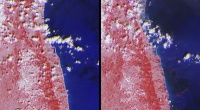
From top to bottom, each image extends from just north of the Abukuma River (about 21km, or 13 miles, south of Sendai) to south of the town of Minamisoma located in Japan’s Fukushima Prefecture (about 70km, or 44 miles, south of Sendai).
The images cover an area of 78km (48 miles) by 104km (65 miles).


April 1886: the Brunkebergs tunnel
First ever example of a ground source heat pump?