The research at Manam volcano in Papua New Guinea will also give scientists an improved understanding of how volcanoes contribute to the global carbon cycle.
Drone versus the volcano: UK team feels the heat
The international team’s findings, published in Science Advances, show for the first time how it is possible to combine measurements from the air, earth and space to learn more about the most inaccessible, highly active volcanoes on the planet.
Researchers from Manchester University joined a large international team for fieldwork in Papua New Guinea, and afterwards made satellite-based measurements of sulphur dioxide gas emissions using the European Space Agency (ESA) instrument TROPOMI.
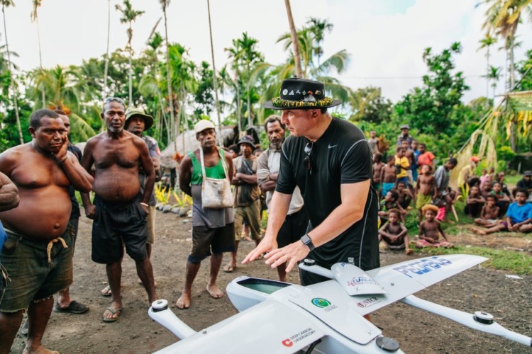
The ABOVE project involved specialists from the UK, USA, Canada, Italy, Sweden, Germany, Costa Rica, New Zealand and Papua New Guinea, spanning volcanology and aerospace engineering.
They co-created solutions to the challenges of measuring gas emissions from active volcanoes, through using modified long-range drones.
In a statement, Dr Brendan McCormick Kilbride, Presidential Fellow at Manchester University said: “The really exciting advance here is that we can use drones to achieve measurements of gas emissions that are otherwise impossible. In settings like Papua New Guinea, where highly active volcanoes can be extremely isolated, adopting this technology has immense potential for volcano monitoring at relatively low cost.”
By combining in situ aerial measurements with results from satellites and ground-based remote sensors, researchers can gather a much richer data set than previously possible. This enables them to monitor active volcanoes remotely, improving understanding of how much carbon dioxide (CO2) is being released by volcanoes globally and where this carbon is coming from.
With a diameter of 10km, Manam volcano is located on an island 13km off the northeast coast of the mainland, at 1,800m above sea level. Previous studies have shown it is among the world’s biggest emitters of sulphur dioxide, but nothing was known of its CO2 output.
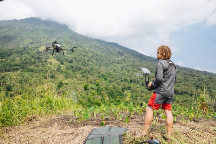
Volcanic CO2 emissions are challenging to measure due to high concentrations in the background atmosphere. Measurements need to be collected very close to active vents and, at hazardous volcanoes like Manam, drones are the only way to obtain samples safely. Yet beyond-line-of-sight drone flights have rarely been attempted in volcanic environments.
Adding miniaturised gas sensors, spectrometers and sampling devices that are automatically triggered to open and close, the team was able to fly the drone 2km high and 6km away to reach Manam’s summit, where they captured gas samples.
Calculating the ratio between sulphur and carbon dioxide levels in a volcano’s emissions is critical to determining how likely an eruption is to take place, as it helps volcanologists establish the location of its magma.
Volcanic emissions are a critical stage of the Earth’s carbon cycle - the movement of carbon between land, atmosphere, and ocean – but CO2 measurements have so far been limited to a relatively small number of the world’s estimated 500 degassing volcanoes.
ABOVE was funded by the Alfred P. Sloan Foundation.
Project to investigate hybrid approach to titanium manufacturing
What is this a hybrid of? Superplastic forming tends to be performed slowly as otherwise the behaviour is the hot creep that typifies hot...