The SmartICE project is providing Arctic inhabitants with real-time data on their capricious landscape
At the recent United Nations climate conference in Bonn, Dr Trevor Bell was slightly taken aback that some people think polar bears are the only thing under threat in a warming Arctic.
“It was a little bit revealing how little people know about the Arctic,” he told The Engineer. “The idea that people live in the Arctic seems to be quite a surprise to some people.”
Bell was in Bonn to collect a UN Momentum for Change Climate Solutions Award for SmartICE, a project he heads up at Newfoundland’s Memorial University. A physical geographer and field scientist, much of his working life has been spent studying the landscapes and settlements of the Arctic and the rapid changes affecting the region. While media glare tends to focus on the fate of the polar ice caps, coastal ice on the fringes of the continents impacts the lives of Arctic inhabitants more directly.
“Nearly all of the communities are coastal and they rely on what’s called landfast ice, not the polar ocean which is mobile ice,” Bell explained. “Landfast ice is ice that’s frozen to the coast, if you like. It grows and disappears every year.”
That ice is used by animals and humans to travel and hunt, offering flatter and more direct routes than the land. Although there have always been dangers associated with this dynamic landscape, recent years have become increasingly unpredictable, according to Bell.
“People have said that within the last decade or so there have been dramatic changes,” he said, “such that ice might not freeze up for a month later (than usual), it may break up a month earlier, and you’re finding places on the ice that are much, much thinner in places that should be thick.”
The ice is being diminished as a result of both warming air and ocean temperatures in a double-pronged attack. Where the effect is primarily from below, no signs of thinning on the surface may be visible, leading to a particularly potent danger.
“It’s been a dramatic change and it’s catching people off guard,” said Bell. “We’ve had accidents here in Canada. In Hudson Bay area this year three people died going through the ice on parts that they thought were safe.”
Seasonal shifts
Search-and-rescue operations in the Canadian Arctic have doubled in the last 10 years. About a third of those incidents tend to occur during the critical ‘shoulder’ seasons when the ice is forming and breaking up. Surveys in recent years indicate that one in 12 people are falling through the ice annually, with two-thirds expressing fear about travelling on the ice.
Having worked with the Inuit for many years, Bell was approached regarding how technology might be used to complement traditional indigenous knowledge about sea ice. The result is SmartICE, a system that uses sensors and satellite imagery to provide the communities with better information about the landscape they so fundamentally rely on. “That first reach-out was from the Inuit community, so that is an important part of SmartICE,” explained Bell. “It’s a service for communities by communities.”
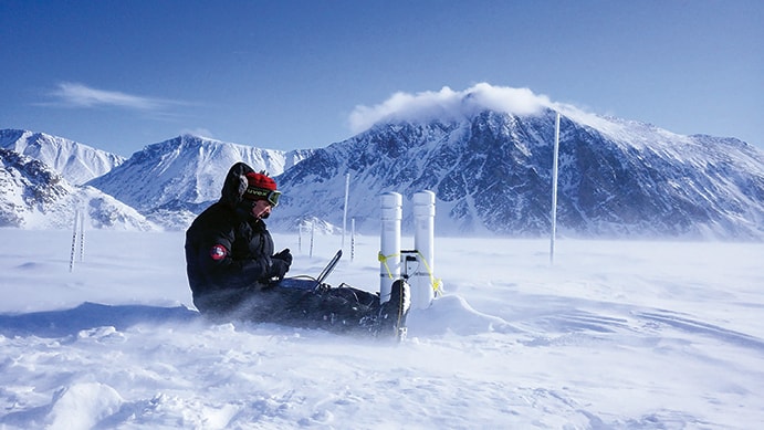
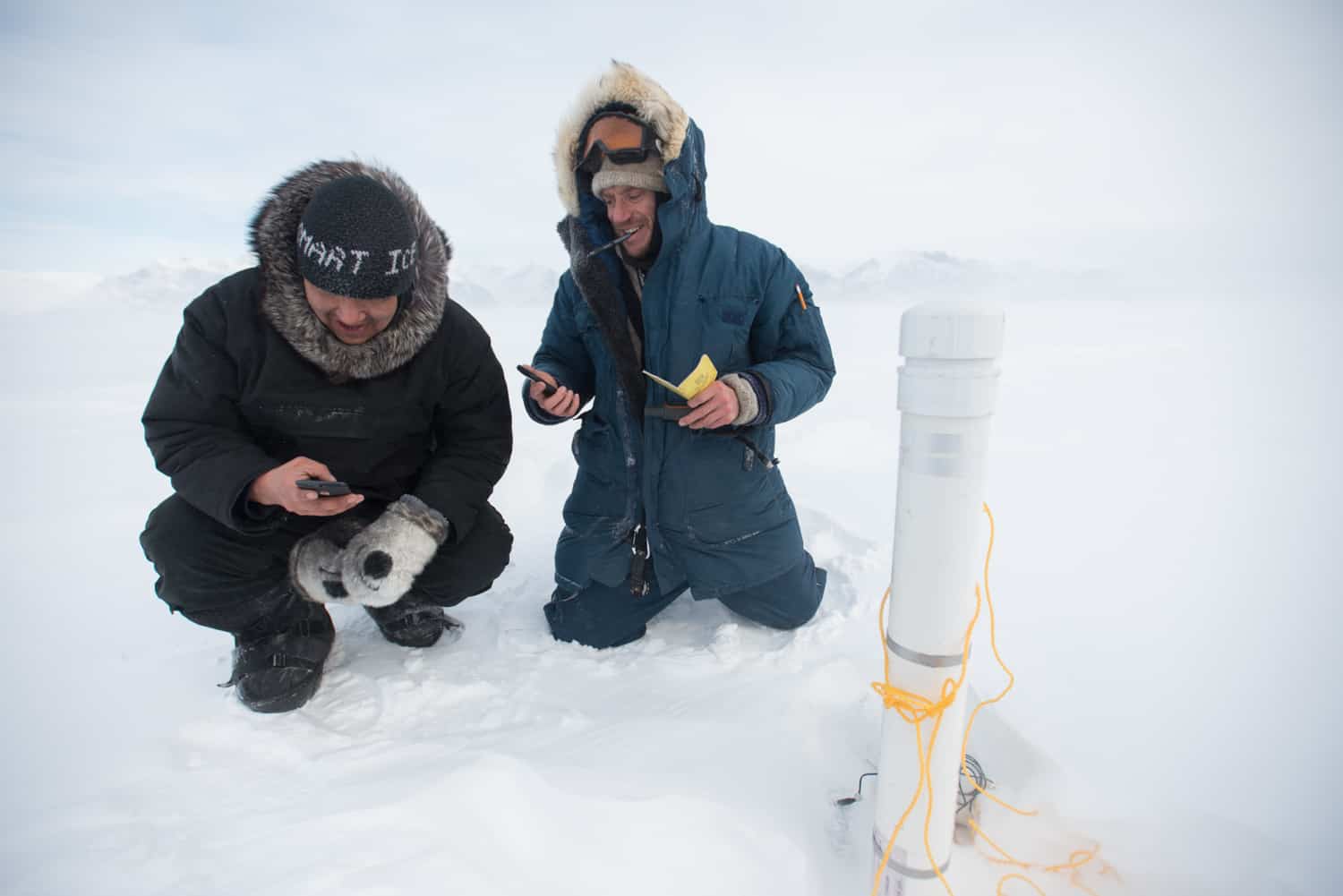
The system uses two types of sensor to help identify potentially dangerous spots where the ice is thin. SmartBUOYS are long tall sensors that penetrate through the ice to the sea below in locations decided upon by the Inuit. Rather than taking a measurement of the physical thickness directly, the buoys measure the difference in temperature above and below, with thickness calculated from the temperature gradient. Sea temperatures tend to remain relatively constant around -1˚C, but air temperature can reach as low as -50˚C depending on the season.
“It’s that change in the temperature from the warm ocean up into the cold atmosphere that allows us to measure the sea ice thickness,” said Bell. “That then is communicated by satellite back to us or back to the community, and we translate that into an evolving diagram that shows the progression of the ice thickness and snow depth over the season.”

Depending on how big an area a community travels across, between five and 10 of the stationary buoys might be deployed. SmartICE also uses a mobile sensor called SmartQAMUTIK (from the Inuit word for sled) that can be towed behind a snowmobile. Rather than measuring temperature, it uses a conductivity metre to detect the bottom of the sea ice. The difference in conductivity between the saline water and the sea ice – which ejects most of its salt when it freezes – allows thickness to be gauged, according to Bell.
“As the snowmobile travels around on the trails, it’s providing – in real time – the ice thickness to the operator,” he said. “But it’s also collecting that information so that when it comes back into the community, it’s automatically detected by a WiFi system that downloads it, processes it and sends it back to the community as a colour-coded travel-track… so people can immediately see what the ice thickness is and how it varies.”
The edge of the landfast ice is biologically rich, and this is where much community hunting and fishing takes place. But it’s a double-edged sword, as this is also some of the most treacherous territory. It being the Arctic, there’s also 24-hour darkness to contend with for around three months of the year. Spring brings a brand-new hazard in the form of surface slush. When it’s deep enough, snowmobiles can get stalled in this slush, often with disastrous consequences. If you’re a long way from home, with no snowmobile and soaked to the bone, exposure can lead to amputations and even death.
“That’s why the freeze-up and the break-up, those shoulder seasons, are when there’s the most search-and-rescue incidents,” said Bell.
Radar imagery
The sensor data gathered directly from the ice is supplemented by radar imagery from the European Space Agency’s Sentinel-1 satellite. This helps to identify ‘no go’ and ‘slow go’ areas, as well as areas showing typical conditions for that time of year. Currently, these images are accessed about once a week, but this will soon become more frequent with new satellites coming online.
Alongside a UN Momentum for Change Award, the project received the 2016 Arctic Inspiration Prize. Increased prominence has brought increased demand, and Bell receives requests to join the programme on a weekly basis. This winter, SmartICE should be operating in at least eight communities, but there’s another dozen on a waiting list. How to fund it all has become a key challenge.
As well as the social and cultural benefits the programme enables, there is also a solid brass-tacks argument. Search-and-rescue operations in the Canadian Arctic are eye-wateringly expensive, as coast guard bases are located almost exclusively in the south. A CH-149 Cormorant rescue helicopter takes 12 hours to reach some of the northernmost communities. Choppers sometimes have to be accompanied by Hercules planes carrying supplementary fuel and a second search-and-rescue flight crew. If SmartICE prevented a single call-out, it would virtually pay for itself.
“We’re talking about hundreds of thousands of Canadian dollars to do that, which in itself would pay for the operation of SmartICE for a year, in potentially multiple communities,” said Bell. “Unfortunately, of course, climate change isn’t going to get any better, it’s probably going to get more intensive moving forward. We’re going to have to, obviously, adapt and scale up our services as each winter continually gets tougher for sea ice travel.”


Project to investigate hybrid approach to titanium manufacturing
What is this a hybrid of? Superplastic forming tends to be performed slowly as otherwise the behaviour is the hot creep that typifies hot...