
UK researchers create world’s first country-wide land subsidence map
Researchers at the University of Nottingham have used a novel satellite data analysis technique to create a detailed subsidence map of the whole of Scotland.
Produced from over 2.5TB of radar data acquired over two years by the Sentinel-1 satellite, part of the EU’s Copernicus programme, the map is claimed to be the first of its kind to show a detailed nationwide picture of land motion and subsidence.
The technology behind the map could help developers of energy and transport infrastructure – such as the impending HS2 project - improve their understanding of land subsidence and mitigate against the risks this poses at a far earlier stage in a project’s development.
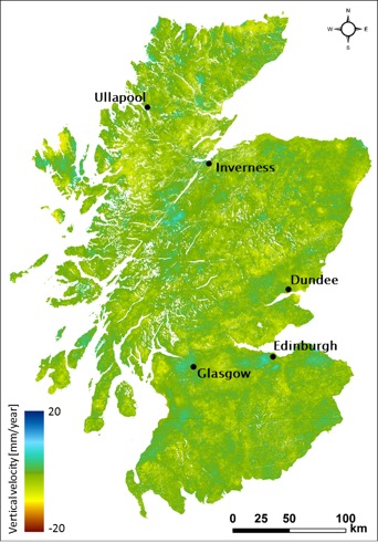
The relative land motion map of Scotland for 2015-2017. Subsidence is indicated by the red and yellow colours, blue indicates uplift, whereas green represents stable ground.
Whilst existing land-motion studies have tended to focus on urban areas, the Nottingham-developed map has also been able to look in detail at rural areas thanks to a technique known as Intermittent Small Baseline (ISBAS) analysis developed by University of Nottingham spin-out Geomatic Ventures Ltd (GVL).
Register now to continue reading
Thanks for visiting The Engineer. You’ve now reached your monthly limit of news stories. Register for free to unlock unlimited access to all of our news coverage, as well as premium content including opinion, in-depth features and special reports.
Benefits of registering
-
In-depth insights and coverage of key emerging trends
-
Unrestricted access to special reports throughout the year
-
Daily technology news delivered straight to your inbox


UK Enters ‘Golden Age of Nuclear’
The delay (nearly 8 years) in getting approval for the Rolls-Royce SMR is most worrying. Signifies a torpid and expensive system that is quite onerous...