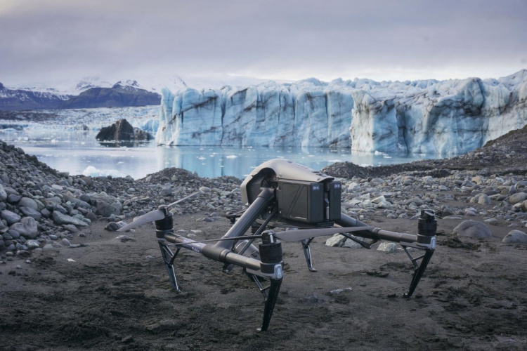
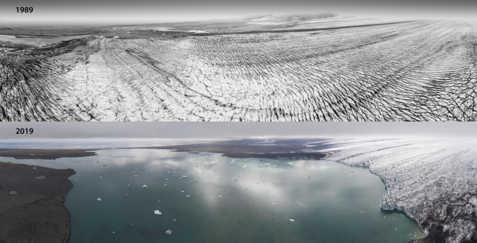
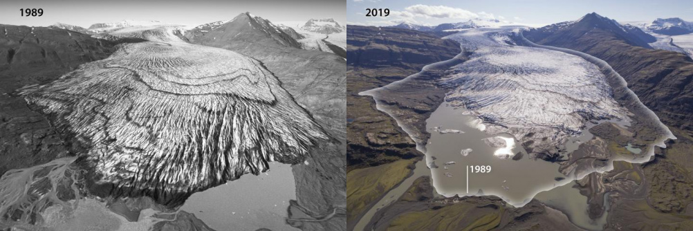
Developed by Dr Kieran Baxter at the University of Dundee, the method involved processing aerial mapping photographs taken by the National Land Survey of Iceland into 3D images using photogrammetry software. Drones were used to capture images of the same areas of glaciers today, and then composite images were created showing the same glaciers 30 years apart, highlighting the massive ice loss that has occurred. While the photogrammetry technique has previously been used to measure historical ice surfaces, this is the first time it has been used to visually compare glaciers across time.
Insects inspire swarm of search and rescue drones
Drones fitted with thermal-imaging cameras measure orangutan numbers
“We have been working to produce images that are both engaging and easy to understand,” said Dr Baxter, a researcher from the 3DVisLab at Dundee’s Duncan of Jordanstone College of Art & Design. “It is important to show how climate change is physically and visibly affecting the region. To do this, we developed a novel process based on principles that are used by glaciologists to measure ice-volume loss.
"This method allows us to compose unique aerial views of past landscapes and to see how they have changed over the last 30 to 40 years. This period, which is within living memory for many people, has seen accelerated melt in Southeast Iceland.”
Iceland’s Vatnajökull ice cap, which covers an area of 7,700 km², has dropped by around 20m on average over the last three decades. The height of the outlet glaciers pictured in the image comparisons has dropped even more, from 100 to 150m in some areas near the termini. The glacier ice margins are now retreating tens and sometimes hundreds of metres each year. Since the turn of the century, the area of the icecap has been reduced by over 400 km².
The images produced by Dr Baxter were shared by the Icelandic Meteorological Office to coincide with the IPCC's 'Special Report on the Ocean and Cryosphere in a Changing Climate'. It is hoped that they will help promote public awareness of climate science and glaciology in Iceland and beyond.
"Outreach about changes in the climate and the ongoing downwasting of glaciers of Iceland has become increasingly important in our glaciological work at the Icelandic Meteorological Office in recent years,” said Dr Tomas Johannesson, coordinator of Glaciological Research at the Icelandic Meteorological Office.
“We have limited background and expertise in the creation of effective visual outreach material that shows the dramatic changes of the glaciers. Our collaboration with Kieran Baxter and the University of Dundee is important for our public outreach and has proved effective to explain the changes that have occurred in recent decades.”


Nanogenerator consumes CO2 to generate electricity
Nice to see my my views being backed up by no less a figure than Sabine Hossenfelder https://youtu.be/QoJzs4fA4fo