Near-real-time map depicts earthquake aftershocks
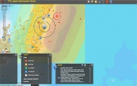
A near-real-time map of the aftershocks occurring globally following the 8.9-magnitude earthquake that rocked Japan has been created by researchers at Texas Tech University’s Center for Geospatial Technologies.

Kevin Mulligan, director of the centre, said the map was developed following a lack of new information presented on major news outlets.
The map connects to near-real-time remote feeds from the US Geological Survey’s (USGS’s) Earthquake Hazards Center and the National Oceanic and Atmospheric Administration’s Tsunami Warning Center.
’This map is a dynamic map surface that shows the distribution of recent earthquakes from a USGS live remote feed,’ Mulligan said.
’It provides map information, satellite imagery and location of recent earthquakes. As part of this major earthquake, there are hundreds of aftershocks that follow,’ he added.
The Texas Tech University map can be viewed at: http://mapserver.gis.ttu.edu/japanquake
Register now to continue reading
Thanks for visiting The Engineer. You’ve now reached your monthly limit of news stories. Register for free to unlock unlimited access to all of our news coverage, as well as premium content including opinion, in-depth features and special reports.
Benefits of registering
-
In-depth insights and coverage of key emerging trends
-
Unrestricted access to special reports throughout the year
-
Daily technology news delivered straight to your inbox


Water Sector Talent Exodus Could Cripple The Sector
Well let´s do a little experiment. My last (10.4.25) half-yearly water/waste water bill from Severn Trent was £98.29. How much does not-for-profit Dŵr...