3D Laser Mapping (3DLM) is a cutting-edge innovator, specialising in technology to help capture all terrains in 3D. From environmental monitoring software to laser scanning systems, the company’s technology supports the delivery of data across a range of industries including mining, urban infrastructure, geohazards and the emergency services.
Spotting a gap in the market for a flexible mobile mapping system, 3DLM decided to develop a system on an entirely new platform. Lightweight and portable, ROBIN is designed to be operated by one person, enabling fast deployment to site even in remote and difficult to access locations, making it suitable for a range of applications and environments. In an emergency situation, for example, to have an accurate and detailed 3D model of the site can be immensely helpful.
“ROBIN is the only mobile mapping system on the market that allows for mapping via a backpack, vehicle mount and helicopter,” explains Shaun Stone, Project Engineer, 3D Laser Mapping Systems. “the multi-platform laser scanning capability of the technology means that we can capture all required mobile mapping data on any site by driving, walking or flying over it.”
ROBIN integrates a 12 MP camera (for drive) and 18MP (for walk and fly), two GNSS antennas, GIS grade IMU navigation system, touch screen control unit, three mounting systems, capture software, a post-processing software package and has a field of view of 330 degrees. Long-range and precision versions are also available.
By combining a high accuracy survey-grade inertial navigation system and two LiDAR (light detection and ranging) scanner heads each measuring 550,000 points per second, the technology captures an extremely high-resolution dataset with achievable accuracies to within 10-20mm. With several mounting options, ROBIN can be used across multiple platforms, providing the ability to map areas via land, road or air.
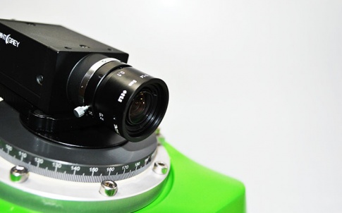
An essential requirement during the development process was to ensure that the system’s weight and overall size were to be kept to a minimum. The camera is mounted directly above the inertial navigation unit, so that it can be rotated to view any angle desired with minimal data entry when processing 3D data. It is mounted on top of the system in such a way that it is always positioned vertically to the ground.
“For the camera mounting, we wanted a bearing that was small and lightweight,” explains Stone. “Having used igus bearings on previous prototypes, igus was our first choice - we knew their products would meet these requirements.” To minimise the overall weight of ROBIN further, 3DLM produced a custom-made GRP (glass reinforced plastic) housing upon which the camera is mounted.
The iglidur PRT slewing ring bearing selected allows the camera to be positioned at any angle and locked in place using a single Allen key. In order for the user to see the rotation angle of the camera, which is used when processing the data, the bearing was pre-engraved by igus to show the degrees of rotation. This proved very beneficial to 3DLM as only one supplier was required for the finished part. The bearing is also inherently corrosion resistant and therefore protected from adverse weather conditions and, because it’s self-lubricating, it requires no maintenance.
Since its launch, ROBIN has been used to scan and monitor railway sidings, which helps to assess repairs needed after something like a landslide. As part of an ongoing study with Durham University, ROBIN with the helicopter mounting is also being used to scan and monitor coastal erosion along the Whitby coastline. 3DLM will continue to work with igus on future projects whenever there is a need for bearings and motion components.


Water Sector Talent Exodus Could Cripple The Sector
Maybe if things are essential for the running of a country and we want to pay a fair price we should be running these utilities on a not for profit...